|
Generally...
A
guide to the smaller villages.
The
Fly River.
The
Coastline.
An
overview of Umbagollah's natural wonders. |
 |
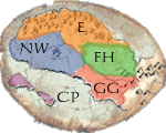
The Province of
Ex.
Occupied almost entirely by a single massive
forest, the Province of Ex houses our capital city and seat of
government.
The city
of Ex. A spindly and mysterious place.
The
Forest of Ex. |
 |
The Province of Gum Gooloo
Gum Jublet.
This sunlit province was the first area
of Umbagollah to be settled.
The
city of Gum Gooloo Gum Jublet. Our first city, warm and
verdant.
Gum Gooloo is also home to The
Cultural and Natural History Museum. This is the place
where stories and documents are kept.
Two
Shows Ranges.
The
Fly Ravine.
The South Thrip River.
Furl, where paper is made. |
 |
The North West
Province.
The North West harbours Umbagollah's most
violent town, much to the shame of its hundreds of peaceful
farming communities.
The
town of Jail. A lawless seaport.
The
North-West Flatlands.
The
Wandering Woods.
The
Kadmudia Gouache mudflats.
West
Drosophilia River. |
 |
The Province of the Falling
Hills.
Windy, wild and mad, the Falling Hills are
inhabited by eccentrics and governed by a poet.
The
Falling Hills.
The
High Country.
The village of Top
Of The Hill.
East
Drosophilia River.
The Kelp Forests.
North Thrip River. |
 |
The Province of Cumber
Poidy.
This tiny province consists of two islands, a
lot of sea and a community that lives in a cave system.
The
town of Cumber Poidy. A town underground.
The
Isle of Yunck and Aorist Island.
Pithistle Strait. |
 |


